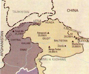

Gilgit - Baltistan
(Northern Areas of Pakistan)
 Northern Areas
of Pakistan consist of Gilgit - Baltistan region, sandwiched between the Hindukush and
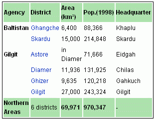
Karakoram on the north and western Himalaya on the south. It borders to the north with Afghanistan and China, to the south with India and Azad Kashmir and to the west with NWFP. The Northern Areas comprise the two districts of Baltistan and the three districts of Gilgit (where the capital is located). Hunza, an independent principality for 950 years which only came under Pakistani rule in 1974, is also located in this region. The
Northern Areas collectively comprise a territory of some 72,496 sq km.
The Northern Areas border the Wakhan corridor of Afghanistan to the
northwest, the Xinjiang territory of China to the northeast, the
Indian-controlled state of Jammu and Kashmir to the southeast, the region of
Pakistani-administered Azad Kashmir to the southeast and the North-West
Frontier Province to the west. The main political centres are the towns of
Gilgit, Skardu and Chilas.
Northern Areas
of Pakistan consist of Gilgit - Baltistan region, sandwiched between the Hindukush and
Karakoram on the north and western Himalaya on the south. It borders to the north with Afghanistan and China, to the south with India and Azad Kashmir and to the west with NWFP. The Northern Areas comprise the two districts of Baltistan and the three districts of Gilgit (where the capital is located). Hunza, an independent principality for 950 years which only came under Pakistani rule in 1974, is also located in this region. The
Northern Areas collectively comprise a territory of some 72,496 sq km.
The Northern Areas border the Wakhan corridor of Afghanistan to the
northwest, the Xinjiang territory of China to the northeast, the
Indian-controlled state of Jammu and Kashmir to the southeast, the region of
Pakistani-administered Azad Kashmir to the southeast and the North-West
Frontier Province to the west. The main political centres are the towns of
Gilgit, Skardu and Chilas.
Once, the southern route of the ancient Silk Road passed through these areas, travelled by merchants from many far-off places who stopped here and inter-married with the locals. The relatively fair-skinned and light-haired people of the area are often believed to be the descendants of the Greeks who, beginning with the soldiers of Alexander the Great, and continuing in the Greco-Buddhist period, settled in the region. The population of these areas has links to many diverse linguistic, ethnic and religious groups. Urdu is the lingua franca of the region, understood by most inhabitants. The "Shina" language is the language of 40% of the population, spoken mainly in Gilgit, throughout Diamer, and some parts of Ghizer. The "Balti" language with a similar accent, is spoken or understood by most of the population of Baltistan. Other rather localised languages include "Wakhi" spoken in upper Hunza, and some villages in Ghizer, while Khowar is the major language of Ghizer. "Burushaski" is an isolated language spoken in Hunza, Nagar, Yasin (where Khowar is also spoken), some parts of Gilgit and some villages of Punyal. Another interesting language is Domaaki, spoken by the musician clans of the region.
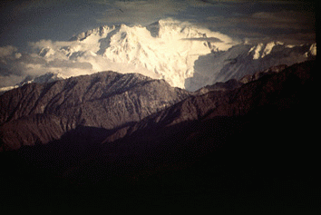
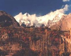
The region is home to some of the world's highest mountain ranges — the main ranges are the Karakoram and the western Himalayas. The Pamir mountains are to the north, and the Hindu Kush lies to the west. Five of the Eight-thousander (above 8,000m) peaks of the world are in the Northern Areas of Pakistan. Some of the world's largest glaciers outside the polar regions are also in Northern Areas, such as Baltoro Glacier, Biafo Glacier and Hispar Glacier. Amongst the highest mountains are K2 and Nanga Parbat, one of the most feared mountains in the world. The famous Karakoram Highway (KKH), the highest international road in the world, also pass through the NA to connect China with Pakistan through the Khunjrab pass, which is at an estimated altitude of 4850 meters. The pride pinnacles of the Northern Areas are:-
K2, 2nd highest of the world at 8,611Metres
Nanga Parbat, 9th highest of the world at 8,125 Metres
Gasherbrum I, 11th highest of the world at 8,080 Metres
Broad Peak, 12th highest of the world at 8,047 Metres
Gasherbrum II-IV, 13th-17th highest of the world at 8,035 Metres - 7,932 Metres
Masherbrum (K1), 22nd highest of the world at 7,821 Metres
Rakaposhi, 27th highest of the world at 7,788 Metres
Deosai Plains is located above the tree line, the second highest plains of the world at 4,115 m (13,500 feet) are in the South of Skardu and in the East of the Astore Valley. The area was declared as a National Park in 1993. The Deosai Plains cover an area of almost 3,000 square kilometers. The plains remain snow-bound for good about six months from November to May.
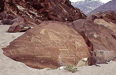
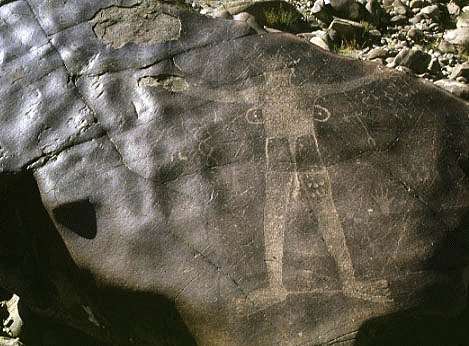
Left: Three stupas on the 'altar-rock' near Chilas (800 AD). Stupa in the middle is approximately 1 metre high. Right: Engravings on Rocks - KKH
There are more than 20,000 pieces of rock art and petroglyphs all along the Karakoram Highway in Northern Areas of Pakistan that are concentrated at ten major sites between Hunza and Shatial. The carvings were left by various invaders, traders and pilgrims who passed along the trade route, as well as by locals. The earliest date back to between 5000 and 1000 BCE, showing single animals, triangular men and hunting scenes in which the animals are larger than the hunters. These carvings were pecked into the rock with stone tools and are covered with a thick patina that proves their age.
Northern Areas Development Gateway (NADG) has been set up to enhance the access to development information related to Northern Areas of Pakistan. It is a pioneering web-based knowledge initiative presenting information on a range of issues pertaining to this region.
|
The Gilgit-Baltistan Empowerment and Self Governance Order, 2009 approved by the federal cabinet on 29 August 2009, through which Pakistan officially granted full autonomy to the former Northern Areas. Ending their struggle for autonomy since 1947. Furthermore, the name of the Northern Areas was changed to "Gilgit Baltistan" has received mixed initial reactions. At least one change has been universally applauded though: renaming the Northern Areas Gilgit-Baltistan has met a long-standing demand of the people of the area who chafed under an appellation that was simply the geographical expression of the area’s position vis-à-vis Jammu and Kashmir, i.e. the ‘northern areas’ of Jammu and Kashmir. But while the federal government and its allies have trumpeted the other changes to the administrative structure of Gilgit-Baltistan, the people of the area have been less than impressed. In fairness, the government deserves some credit for taking the step of recognizing that there is such a thing as Gilgit-Baltistan and moving to redress at least some of the local grievances against the system of governance and the delivery of justice. Yet, we are also sympathetic to the local claim that they are denied any clear constitutional status and the rights that would flow from it and the fact that the absence of a high court in Gilgit-Baltistan means the locals have to go to Islamabad to seek justice. Information Minister Qamar Zaman Kaira, who is also holding the charge of Minister for Kashmir Affairs and Northern Areas, and Minister of State for Information has also been named as the first governor of the Gilgit-Baltistan |
|
Related Links: | See More | Detailed Map Northern Areas | Northern Areas of Pakistan | |
|
| HOME PAGE | FATA | NWFP | PUNJAB | SIND | Copyright©JalalsPages - 2005 - 2009 |