Kohat
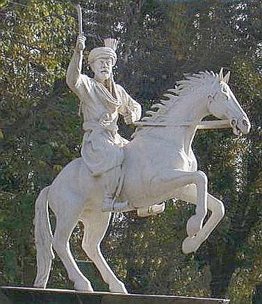
Statue of Ajab Khan Afridi
( A warrior who forced the entire British
administration of the district to surrender to his demands)
Kohat is a famous city of NWFP, located 37 miles south of Peshawar by the Kohat Pass. The Kohat district is spread over an area of some 3000 square miles. The city centres around a British-era fort, various bazaars, and a military cantonment. There are a number of shrines of revered religious scholars that include sufi saint Haji Bahadar Ali Abdullah Shah and Mian Fateh Shah. The town boasts many mosques and schools. A British built narrow gauge railway runs through the town. To the north of the city lies Kohat Pass, through which a military road was opened in 1901. No one really knows how old is Kohat. It is said that in the Buddhist times, two Rajas named Adh and Kohat settled along with the northern border of the district. Raja Kohat gave his name to the town of Kohat , and Raja Adh to the ruins of an old fort on the hill side north of the Muhammadzai , a village four miles to the west of Kohat. In 1505 AD, the Mughal Emperor Zaheer ud Din Babar is also said to have visited the place. In the beginning of 19th century Kohat came under the control of Sikhs when Ranjit Singh first marched to Peshawar in 1819 . In 1832 Azim Khan was defeated by Ranjit Singh with great slaughter near Naushera , after which Peshawar Sirdars became tributary to the Sikh Government , who sent an army each year to collect the revenue. In 1834 Sikh General Autar gained possession of Peshawar and a Sikh Autar Singh Sindhanwalia became the governor of Kohat. The town finally fell to ultimately fell to Khan of Teri in 1836.
Kohat however came to prominence during the British rule of India when the British entrenched themselves with the Afghans in the three Afghan wars. Kohat was annexed to the British dominion on 28th March 1849 with the rest of Punjab and an Assistant Commissioner was posted here to run the administration and to look after the British interests. In the initial stages of the British administration, the locals of the area posed considerable problems, although some of the tribe later joined with the British Government and helped them in running the area. Nevertheless, the British were never at peace in this part of their Kingdom as resistance and opposition always cropped from one quarter or the other. But their tactics of "Divide and Rule" ultimately strengthened their hold over the region. They put one tribe against the other by giving preference to one against the other and finally succeeded in administration them. An example of unrest against the British empire are the actions of Afridi Ajab Khan, who forced the entire British administration of the district to surrender to his demands.
The RAF commissioned Kohat as an airfield for operational purposes in 1922 to meet the threat posed by tribesmen of the northern and western areas of the Frontier Province. Kohat was one of the three stations in the region, the other two being Peshawar and Risalpur. In the 20s, Kohat was The administrative wing, maintenance wing fighter-bomber base with two squadrons of Westland Wapitis - Nos. 27 and 60 RAF Squadrons. According to records , the headquarters building, aircraft and supply hangars, Ml room, armory, swimming pool and many other buildings were erected in 1925. Double storey barracks Nos 90 and 95, and living out JCOs' accommodation were built in 1940. In 1938 there were two different squadrons at the station, Nos 16 and 17 Squadrons RAF with three flights each and with each flight comprising 8 aircraft. The aircraft were mainly Wapitis and Audaxes, with a few Blenheims. All pilots and airmen were British. During WWII, several RAF and IAF squadrons staged through Kohat as part of their cycle of rest periods between deployments on the Burma front. The same air filed is presently under use by the PAF as a satellite base used for emergency landing and recovery of aircraft during both peacetime and wartime. Kohat is served by a single 8,100 foot long runway.
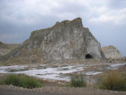
The Kohat district is located around bare and rock mountain region east of river Indus, dotted with river valleys and deep ravines, beside a few scattered patches of cultivated low land. The eastern or Khattak country especially comprises a perfect labyrinth of ranges, which fall, however,-into two principal groups, to the north and south of the Ten Toi river. The Miranzai valley, in the extreme west, appears by comparison a rich and fertile tract. In its small but carefully tilled glens, the plane, palm, fig and many orchard trees flourish luxuriantly; while a brushwood of wild olive, mimosa and other thorny bushes clothes the rugged ravines upon the upper slopes. Occasional grassy glades upon their sides form favorite pasture grounds for the Waziri tribes. The Ten Toi, rising on the eastern limit of Upper Miranzai, runs due eastward to the Indus, dividing the district into two main portions. The drainage from the northern half flows southward into the Ten Toi itself, and northward into the parallel stream of the Kohat Toi. That of the southern tract falls northwards also into the Ten Toi, and southwards towards the Kurram and the Indus. The frontier mountains, continuations of the Safed Koh system, attain in places a considerable elevation, the two principal peaks, Dupa Sir and Mazi Garh, being 8260 and 7940 ft. above the sea respectively. The Waziri hills, on the south, extend like a wedge between the boundaries of Bannu and Kohat, with a general elevation of less than 4000 ft. The salt-mines are situated in the low line of hills crossing the valley of the Ten Toi, and extending along both banks of that river. The deposit has a width of a quarter of a mile, with a thickness of I000 ft.; it sometimes forms hills 200 ft. in height, almost entirely composed of solid rock-salt, and may probably rank as one of the largest veins of its kind in the world. The most extensive exposure occurs at Bahadur Khel, on the south bank of the Ten Toi. The annual output is about 16,000 tons. Petroleum springs exude from a rock at Panoba, 23 miles east of Kohat; and sulphur abounds in the northern range.
The indigenous people of Kohat and surrounding areas generally live in houses made of clay, like any other part of the province owing to weather severity and poverty, which are usually clustered in villages. A standard house consists of two or three rooms. Hujra is an important feature for a cluster of houses where male members interact and is also used as a guestroom. In urban centers the houses are mostly brick made with modern structure. Men and women wear loose shalwar Kameez while the women folk wrap themselves up with an additional sheet of cloth called " Chaddar " in order to hide her face and figure. Women usually wear an additional cloak, usually black or white in color called "Burqcr". Men also put on Chitrali caps along with woolen shawl in winter.
Beside many quality educational institutions, Kohat is also home to two prestigious military institutions: The Inter Services Selection Board (ISSB) and the Cadet College Kohat. The Kohat University of Science & Technology was established in 2001 and offers advanced studies to the students of the area.
Places of Interest in / around Kohat: The British as the always do, left behind memorials and mementos all along the Peshawar - Kohat road. There is a large setup of Army within old cantonment area. There is also a fort build by the British Government in the city, which now houses Army establishment. Some other places of interest include:
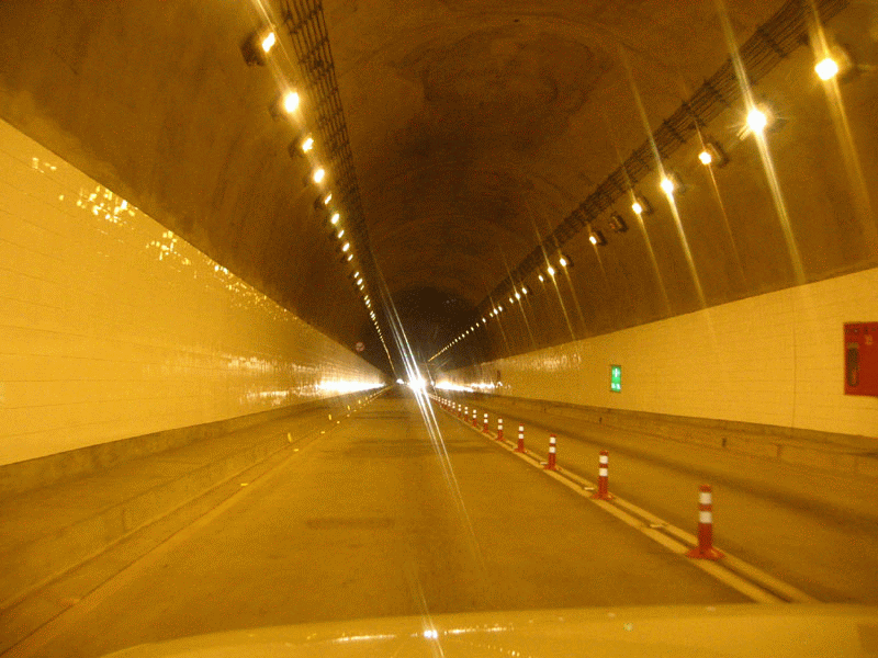
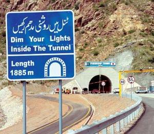
Kohat Tunnel: Till few years
before the travel from Peshawar to Kohat was through treacherous Kohat Pass with
its windings and deadly ravines. But with the construction of almost 2 kilometre
long Kohat Tunnel, with the assistance of the government of Japan, not only the
distance has been made comfortable but also has shortened the time frame as
well.
Read More about Kohat Tunnel ...
Lachi: Lachi lies on the Indus
Highway on the way to Bannu. It has its own town committee with a population of
15,376 (1998 census). The town has all the basic facilities and presently there
is a proposal to convert it into a Tehsil. The population of the area is
pre-dominantly Khattak.
Shakardara: Shakardarra
is the only other
urban centre, which has a town committee in Kohat District. It
also lies toward the Bannu, but is at quite some distance from the main highway.
The population of the town committee is 9,403 (1998census). It has a
conservative Society with pre-dominantly Khattak population.
Khushhal Garh: On the way from Kohat to Islamabad one comes across a small settlement of Khushalgarh, which overlooks the river Indus. The river Indus can be viewed clearly from the rest house, which is perched on a cliff, giving a birds eye view of the river below.
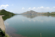
Tanda Dam Lake (left) - Kohat Salt Mine (right)
Tanda Dam: Tanda Dam was built in
1960s near Kohat city towards the Hangu district. It is the main source of
irrigation to adjoining areas. It has lovely surroundings, which attract a large
number of people especially on weekends. The peaceful recreation provided by its
natural beauty is unsurpassed. Tanda dam is a medium sized man-made dam to
supply water and electricity to the region. The area was closed off by the NWFP
Wildlife Department to captive breed rare and extinct animals within the
province. in the scrub forest there are Nilgai or Blue Bulls, Chinkara gazelles
and Hog Deer while on the slopes there are urial - the latter being the only one
out of the 4 to be found in the wild state in NWFP. Birds found here include
grey partridges, chukor, see see, black partridges, doves, larks and other small
birds.
Darra Adam Khel: The narrow
stretch of territory extending from Handi Side Gate (Kotal) to 'Spina Thana'
covering a total distance of about twenty one Kilometers by road is generally
referred to as `Darra' taking its name from the geographical layout of the
area. Darra is famous for the production of arms and ammunition throughout the
country. The technical skill attained by these gunsmiths is acknowledged even in
foreign countries. It has also become a major source of livelihood for the
people of this area.
Related Links: |
General
Description & Geography of Kohat District |
Cadet College Kohat |
Kohat Map |
| A COMPARATIVE STUDY OF STRUCTURAL
STYLES IN THE KOHAT PLATEAU |
|
| HOME PAGE | MORE CITIES | Copyright©JalalsPages - 2009 |